More than 14,000 Acres of the Rio Embudo Watershed burned in the Hermit's Peak-Calf Canyon Fire.
Conditions exist which are likely to produce ash and other burn materials in the Rio Embudo especially during heavier rains and flash flood events.
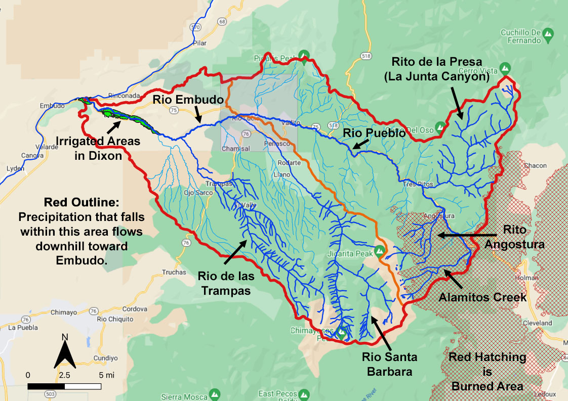
However, all of the burned area is in the Rio Pueblo part of the watershed. So rains in the Santa Barbara and Trampas areas will not involve bringing down any ash. These drainages are all on the west slope of La Jicarita Peak where there was no fire.
But if it is raining on the east slope of Jicarita Peak, in the area along the Rio Pueblo above Tres Ritos, there is potential for ash coming down.
Mayordomos and Parciantes: Click Here to read guidelines for using ashy water for irrigation.
The map below shows that all of the burned area (red hatched pattern) is on the east slope of Jicarita Peak which flows into the Rio Pueblo and then into the Rio Embudo.
Click Here to see a 3-D map of the watershed (May take a little while to load the first time).
Click Here to see a map of burn severity from the Forest Service Burned Area Emergency Response Team (BAER)
Monitoring the Rio Pueblo flow during rain events:
There is a USGS Flow Gage on the Rio Pueblo above Picuris Pueblo (under the bridge to the monastery (old Camp Summer Life). During rain events, it is possible to see current flow rates at the gage. If there is a large surge in the flow, it might indicate a possible flash flood coming from the burned area. Perhaps comisionados and mayordomos in the Embudo Valley might be able to use the readings as an early warning system.
Click Here to see the current Rio Picuris flow rate.
Click Here to see the current Rio Embudo flow rate (This gage is just downstream from Vivac Winery).
Cick here to access flowrates at USGS gages in and around the watershed.
A more detailed description of the watershed is given below the map.
Brief Watershed Description:
Watershed Catchment Area: All surface water within the heavy red boundary line flows downhill to Embudo from both sides of Jicarita Peak and from the north side of Chimayosos Peak. The southeast edge of the watershed ranges in elevation from 9,500 feet to 12,600 feet. The outlet at Embudo where the Rio Embudo joins the Rio Grande is at about 5850 feet.
The heavy orange line that runs through Jicarita Peak divides the watershed into two sub-watersheds.
- Northeast of the orange line, everything flows into the Rio Pueblo above Picuris Pueblo. The principal tributaries are the Alamitos Creek, the Rito Angostura and Rito de la Presa (la Junta Canyon).
- Southwest of the orange line everything flows into the Rio Embudo. The principal tributaries are the Rio Santa Barbara and the Rio de las Trampas. Secondary streams include the Rio Chiquito above Llano de San Juan, the Rio Chamisal and the Rio Ojo Sarco.
As the Rio Pueblo leaves the western edge of the Pueblo (just downstream from Rio Lucio) it is called the Rio Embudo (or on USGS maps: Embudo Creek).
Maps and web presentation created by R. Templeton (rt@rioembudobirds.org)
for the Embudo Valley Regional Acequia Association (EVRAA)
All Rights Reserved